

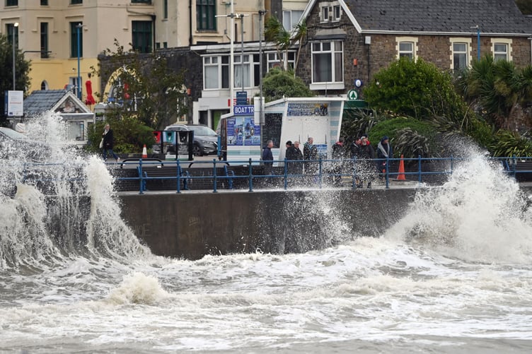
Heavy rainfall from Storm Gerrit is currently impacting Pembrokeshire.
“If you must travel, please take extra care on the roads and allow more time for your journey, as localised flooding is possible,” said a spokesperson for Pembrokeshire County Council.
Dyfed-Powys Police have given an update for Pembrokeshire, stating: “We are receiving a number of calls regarding the amount of standing water on the roads in Pembrokeshire this morning.
“Please take care whilst driving and plan extra time into your journey.”
.jpeg?width=209&height=140&crop=209:145,smart&quality=75)


Natural Resources Wales have issued a flood alert for rivers in South Pembrokeshire, with the authority stating: “A period of adverse weather is affecting this region. River Levels have responded to recent rainfall. River levels are expected to be above normal.
“Flooding of Low-lying land and roads is expected. We will continue to monitor the situation. You can monitor the situation in your area by using our 'River Levels, Rainfall and Sea Data' on our website.”
Met Office Chief Meteorologist Frank Saunders said: “Storm Gerrit will run towards western UK on Wednesday and bring with it potential impacts for much of the UK.
“Winds across southern coastal areas of England will be strong, possibly peaking around 70 mph on exposed coastlines, but more widely around 50-60 mph within the warning area.
“Rain is an additional hazard from Storm Gerrit, with active weather fronts leading to a wet day for many. Snow is also likely to cause problems for some northern areas.”
The Met Office have stated that Wednesday (December 27) will remain unsettled with heavy rain and strong winds.
Today: A wet and windy day with outbreaks of rain sweeping across the country, turning heavier at times through the afternoon before gradually easing. Winds staying strong with the risk of coastal gales but on the mild side. Maximum temperature 13 °C.
Tonight: Some clear spells at first followed by blustery heavy showers, merging to give longer spells of rain and carrying the risk of hail. Very windy, with coastal gales. Remaining mild. Minimum temperature 6 °C.
Thursday: Staying unsettled with frequent heavy showers, merging at times to give longer spells of rain and perhaps the risk of hail. Remaining windy especially over the hills and coasts. Maximum temperature 12 °C.
Outlook for Friday to Sunday: Brighter spells and a few showers on Friday with winds easing. Turning cloudier and breezier on Saturday with rain arriving later followed by showers and sunny spells on Sunday.
For the latest flood alerts and warnings head to: https://orlo.uk/mWJb5
Comments
This article has no comments yet. Be the first to leave a comment.