

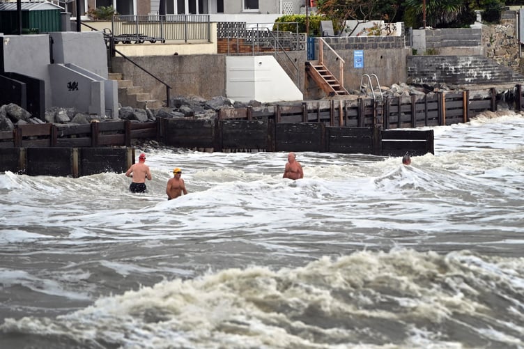
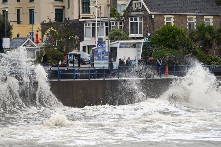
The Maritime and Coastguard Agency and RNLI have issued a warning as Storm Babet brings impactful wet and windy weather to parts of Wales.
Coastguards have stated for members of the public to take care on the coast this week with yellow and amber wind and rain warnings in place for Storm Babet, and have issued coastal safety tips as follows:
• Check the forecasts and tides
• Beware of large waves


• Keep away from cliffs
• Put dogs on a lead
• Avoid sea and river floods
• Emergency? Call 999 for Coastguard
RNLI Water Safety Partner, Sam Hughes, said: “The forecasted strong winds along with heavy rain are likely to cause dangerous conditions for those visiting the coast around the UK and Ireland.
“The RNLI advises staying a safe distance away from the water and cliff edges as the conditions could knock you off your feet or wash you into the sea. It is not worth risking your life.
“If you see someone else in danger in the water, call 999 or 112 and ask for the Coastguard if by the coast, or the fire service if inland. If you have something that floats that they can hold on to, throw it to them. Don’t go in the water yourself – you may end up in difficulty too.”
The RNLI advice is:
• Stay well back from stormy, wintery seas and cliff edges
• Check the weather forecast and tide times before you go out
• Take a phone with you
• In an emergency call 999 or 112 and ask for the Coastguard
The MET Office has stated that Storm Babet will bring increasingly wet and windy weather across the UK on Wednesday, with heavy downpours through the day.
Showery rain is forecast in places of Pembrokeshire this morning with brisk easterly winds. Strong and gusty winds in some western areas, especially over the hills and in coastal regions. Heavy and persistent rain, with local thunder, spreading north this afternoon.
Tonight the rain is clearing northwards through this evening and winds easing. Further showers or rain returning to southern areas later in the night.
On Thursday there will be bright or sunny spells with scattered heavy and slow-moving showers, and perhaps an isolated rumble of thunder. Feeling milder, especially in any sunshine. Generally lighter winds but breezy at times. Maximum temperature 16 °C.
The outlook for Friday to Sunday is mainly cloudy on Friday with rain at times. Brighter and colder over the weekend, but scattered showers are likely, these possibly heavy at times, especially at first. Breezy at times.
Deputy Chief Meteorologist, Steven Keates said: “Storm Babet will bring impactful rain to many parts of the UK, but especially parts of eastern Scotland, Northern Ireland and northern England later this week. Heavy and persistent rain will fall onto already saturated ground bringing a risk of flooding.
“It is important to stay up to date with warnings from your local flood warning agency as well as the local authorities.
“As well as heavy rain, Storm Babet will bring some very strong winds and large waves near some eastern coasts too. Gusts in excess of 60mph are possible in eastern and northern Scotland from Thursday. It is likely Met Office warnings will be updated through the week.”
Comments
This article has no comments yet. Be the first to leave a comment.